Glacial lake outburst flood hazard under current and future conditions: worst-case scenarios in a transboundary Himalayan basin


Natural Hazards and Earth System Sciences
Natural Hazards and Earth System Sciences
- [](https://www.natural-hazards-and-earth-system-sciences.net/home.html)
- Articles & preprintsBrowse Recent By topics Preprints Journal volumes Highlights Editor's choice Articles Research articles Review articles Brief communications Invited perspectives Special issues Published SIs Scheduled SIs How to apply for an SI Collections Published collections How to add an article to a collection EGU Compilations Encyclopedia of Geosciences EGUsphere Popular Most downloaded Most commented Alerts Subscribe to alerts
- PoliciesLicence & copyright General terms Publication policy AI policy Data policy Publication ethics Inclusivity in global research Competing interests policy Appeals & complaints Proofreading guidelines Obligations for authors Obligations for editors Obligations for referees Inclusive author name-change policy
- Peer reviewInteractive review process Finding an editor Review criteria Become a referee Manuscript tracking Reviewer recognition
- AboutAims & scope Subject areas Manuscript types Article processing charges Financial support News & pressMaria Ana Baptista becomes new executive editor of NHESS EGU resources Promote your work Journal statistics Journal metrics Abstracted & indexed Article level metrics FAQs Contact XML harvesting & OAI-PMH
- [](https://editor.copernicus.org/NHESS/)
Article
1. Articles 2. Volume 22, issue 11 3. NHESS, 22, 3765–3785, 2022
[](https://nhess.copernicus.org/)
Multiple terms: term1 term2
_red apples_
returns results with all terms like:
_Fructose levels in **red** and **green** apples_
Precise match in quotes: "term1 term2"
_"red apples"_
returns results matching exactly like:
_Anthocyanin biosynthesis in **red apples**_
Exclude a term with -: term1 -term2
_apples -red_
returns results containing _**apples**_ but not _**red**_:
_Malic acid in green **apples**_
hit s for
[](javascript:void(0))
Close
Refine your search Hide refinement
There are no results for your search term.
Network problems
We are sorry, but your search could not be completed due to network problems. Please try again later.
Server timeout
We are sorry, but your search could not be completed due to server timeouts. Please try again later.
Empty search term
You have applied the search with an empty search term. Please revisit and try again.
Too many requests
We are sorry, but we have received too many parallel search requests. Please try again later.
Searching
Articles | Volume 22, issue 11
- Article
- Assets
- Metrics
Articles | Volume 22, issue 11
https://doi.org/10.5194/nhess-22-3765-2022
© Author(s) 2022. This work is distributed under
the Creative Commons Attribution 4.0 License.
https://doi.org/10.5194/nhess-22-3765-2022
© Author(s) 2022. This work is distributed under
the Creative Commons Attribution 4.0 License.
Articles | Volume 22, issue 11
- Article
- Assets
- Metrics
Research article
|

23 Nov 2022
Research article | |23 Nov 2022
Glacial lake outburst flood hazard under current and future conditions: worst-case scenarios in a transboundary Himalayan basin
Glacial lake outburst flood hazard under current and future conditions: worst-case scenarios in a transboundary Himalayan basin Glacial lake outburst flood hazard under current and future conditions: worst-case scenarios ...Simon K. Allen et al.
[](https://nhess.copernicus.org/articles/22/3765/2022/#top)
Simon K. Allen[](mailto:skallenz@gmail.com),Ashim Sattar,Owen King,Guoqing Zhang,Atanu Bhattacharya,Tandong Yao,and Tobias Bolch
Simon K. Allen
CORRESPONDING AUTHOR
skallenz@gmail.com
×
Department of Geography, University of Zurich, 8057, Zurich, Switzerland
Institute for Environmental Science, University of Geneva, 1205, Geneva, Switzerland
Ashim Sattar
https://orcid.org/0000-0002-9440-2929
×
Department of Geography, University of Zurich, 8057, Zurich, Switzerland
Owen King
×
School of Geography and Sustainable Development, University of St Andrews, KY16 9AL, St Andrews, UK
Guoqing Zhang
https://orcid.org/0000-0003-2090-2813
×
State Key Laboratory of Tibetan Plateau Earth System, Environment and Resources(TPESER), Institute of Tibetan Plateau Research, Chinese Academy of Sciences, Beijing 100101, China
Atanu Bhattacharya
https://orcid.org/0000-0001-7449-3897
×
School of Geography and Sustainable Development, University of St Andrews, KY16 9AL, St Andrews, UK
Department of Earth Sciences and Remote Sensing, JIS University, Kolkata, 700109, India
Tandong Yao
×
State Key Laboratory of Tibetan Plateau Earth System, Environment and Resources(TPESER), Institute of Tibetan Plateau Research, Chinese Academy of Sciences, Beijing 100101, China
Tobias Bolch
https://orcid.org/0000-0002-8201-5059
×
School of Geography and Sustainable Development, University of St Andrews, KY16 9AL, St Andrews, UK
Abstract
Glacial lake outburst floods (GLOFs) are a major concern throughout High Mountain Asia, where societal impacts can extend far downstream. This is particularly true for transboundary Himalayan basins, where risks are expected to further increase as new lakes develop. Given the need for anticipatory approaches to disaster risk reduction, this study aims to demonstrate how the threat from a future lake can be feasibly assessed alongside that of worst-case scenarios from current lakes, as well as how this information is relevant for disaster risk management. We have focused on two previously identified dangerous lakes (Galongco and Jialongco), comparing the timing and magnitude of simulated worst-case outburst events from these lakes both in the Tibetan town of Nyalam and downstream at the border with Nepal. In addition, a future scenario has been assessed, whereby an avalanche-triggered GLOF was simulated for a potential large new lake forming upstream of Nyalam. Results show that large (>20×10 6$> 20 \times 10^{6}$m 3) rock and/or ice avalanches could generate GLOF discharges at the border with Nepal that are more than 15 times larger than what has been observed previously or anticipated based on more gradual breach simulations. For all assessed lakes, warning times in Nyalam would be only 5–11 min and 30 min at the border. Recent remedial measures undertaken to lower the water level at Jialongco would have little influence on downstream impacts resulting from a very large-magnitude GLOF, particularly in Nyalam where there has been significant development of infrastructure directly within the high-intensity flood zone. Based on these findings, a comprehensive approach to disaster risk management is called for, combining early warning systems with effective land use zoning and programmes to build local response capacities. Such approaches would address the current drivers of GLOF risk in the basin while remaining robust in the face of worst-case, catastrophic outburst events that become more likely under a warming climate.
Download & links
- [Article (PDF, 12959 KB)](https://nhess.copernicus.org/articles/22/3765/2022/nhess-22-3765-2022.pdf "PDF Version (12959 KB)")
Download & links
- [Article](https://nhess.copernicus.org/articles/22/3765/2022/nhess-22-3765-2022.pdf "PDF Version (12959 KB)")(12959 KB)
- [Full-text XML](https://nhess.copernicus.org/articles/22/3765/2022/nhess-22-3765-2022.xml "XML Version")
- BibTeX
- EndNote
Share


[](https://nhess.copernicus.org/#)
How to cite.
Allen, S. K., Sattar, A., King, O., Zhang, G., Bhattacharya, A., Yao, T., and Bolch, T.: Glacial lake outburst flood hazard under current and future conditions: worst-case scenarios in a transboundary Himalayan basin, Nat. Hazards Earth Syst. Sci., 22, 3765–3785, https://doi.org/10.5194/nhess-22-3765-2022, 2022.
Received: 08 Jun 2021 – Discussion started: 28 Jun 2021 – Revised: 03 Oct 2022 – Accepted: 23 Oct 2022 – Published: 23 Nov 2022
1 Introduction
Widespread retreat of glaciers has accelerated over recent decades in the Himalaya as in most other mountain regions worldwide as a consequence of global warming (Bolch et al., 2019; King et al., 2019; Maurer et al., 2019; Zemp et al., 2019). A main consequence has been the rapid expansion and new formation of glacial lakes (Gardelle et al., 2011; Nie et al., 2017; Shugar et al., 2020), which has large implications for both water resources and hazards (Haeberli et al., 2016). When water is suddenly and catastrophically released, glacial lake outburst floods (GLOFs) can devastate lives and livelihoods up to hundreds of kilometres downstream (Carrivick and Tweed, 2016; Lliboutry et al., 1977). This threat is most apparent in the Himalaya, where glacial lakes have been increasing rapidly in both size and number (Chen et al., 2021; Wang et al., 2020; Zhang et al., 2015), and where a frequency of 1.3 GLOFs per year has been recorded since the 1980s (Veh et al., 2019). The fact that GLOFs can extend across national boundaries exacerbates the challenges for early warning or other risk reduction strategies, particularly in politically sensitive regions (Allen et al., 2019; Khanal et al., 2015a).
Lakes can develop either underneath (subglacial), at the side of, in front of (proglacial), within (englacial), or on the surface of a glacier (supraglacial), with the dam being composed of ice, moraine, or bedrock. In Asia, most scientific attention has focussed upon the hazard associated with the catastrophic failure of moraine-dammed lakes and particularly those trapped behind proglacial moraines (e.g. Fujita et al., 2013; S.Wang et al., 2015). Such lakes can be very large, with volumes larger than 100×10 6 m 3 and depths exceeding 200 m (Cook and Quincey, 2015), and are susceptible to a range of failure mechanisms owing to the low material strength of the dam structure (Clague and Evans, 2000; Korup and Tweed, 2007). In Asia, as elsewhere in the world, displacement waves generated from large impacts of ice or rock have contributed to the majority of moraine dam failures, occurring predominantly over the warm summer months (Emmer and Cochachin, 2013; Liu et al., 2013; Richardson and Reynolds, 2000). At least 17 GLOF disasters (causing loss of life or infrastructure) have been documented in Tibet since 1935, mostly originating in the central-eastern section of the Himalaya (Nie et al., 2018). Coupled with rapidly increasing population and infrastructural development in the region, an urgent need for authorities to take action and implement timely risk reduction measures has been acknowledged (Wang and Zhou, 2017), considering the best available knowledge on existing threats (e.g. Allen et al., 2019; S.Wang et al., 2015; Wang et al., 2018) but also with a view to the future (Furian et al., 2021; Zheng et al., 2021a).
Despite no clear trend observed in GLOF activity over recent decades in the Himalaya (Veh et al., 2019), the ongoing expansion of lakes towards steep and potentially destabilised mountain flanks is expected to lead to new challenges in the future with implications for hazards and risk (Haeberli et al., 2017). Based on approaches to model the possible future expansion and development of new lakes (Linsbauer et al., 2016), several studies have aimed to quantify the possible implications for GLOF frequency and/or magnitude for different regions (Allen et al., 2016; Emmer et al., 2020; Magnin et al., 2020). For example, in the Indian Himalayan state of Himachal Pradesh, Allen et al. (2016) demonstrated a 7-fold increase in the probability of a GLOF being triggered and a 3-fold increase in the downstream area affected by potential GLOF paths under future deglaciated conditions. Meanwhile, Zheng et al. (2021a) have elaborated such analyses for the entire High Mountain Asia, revealing that the number of lakes posing a transboundary threat within border areas of China and Nepal could double in the future. While such large-scale, first-order studies are important for raising general awareness of the future challenges that mountain regions will face (Hock et al., 2019), there are limitations in the extent to which these studies can directly inform planning and response actions at the ground level.
The need for forward-looking, anticipatory approaches to hazard and risk modelling, including attention to possible worst-case scenarios, is clearly recognised within international guidelines on glacier and permafrost hazard assessment (GAPHAZ, 2017). However, practical examples on how to account for worst-case scenarios and future lake development in local GLOF hazard assessment and risk management have been rarely demonstrated. International best practice is framed by both a first-order assessment undertaken at large scales (to identify potentially critical lakes), followed by a detailed assessment for these lakes using numerical models to simulate downstream flood intensities as a basis for hazard mapping (GAPHAZ, 2017). This is a common approach for existing threats, for which the time, data, and expertise needed to invest in comprehensive hazard modelling and mapping can be well justified for a lake that is known to be critical; yet worst-case scenarios are often neglected and may far exceed historical precedence. For future lakes, where the timing of lake formation is typically highly uncertain, there remains a methodological gap in the hazard assessment process, as authorities are unlikely to undertake sophisticated hazard mapping for a threat that may not even eventuate. In this study we aim to address these gaps by providing an illustrative example of how a worst-case outburst scenario from a potential future lake can be systematically assessed alongside the threat posed by current lakes, before discussing the relevance of such an assessment for disaster risk management in a transboundary context.
Focusing on the transboundary Poiqu river basin in the central Himalaya, the specific objectives of the study are to (1)apply systematic criteria to establish worst-case outburst scenarios and assess the magnitude of downstream impacts from two potentially critical lakes, considering also the effect of recent remedial measures at one of the lakes, (2)compare the results with a potential outburst from a large lake that is anticipated to develop in the future, and (3)discuss the implications for early warning or other risk reduction strategies.
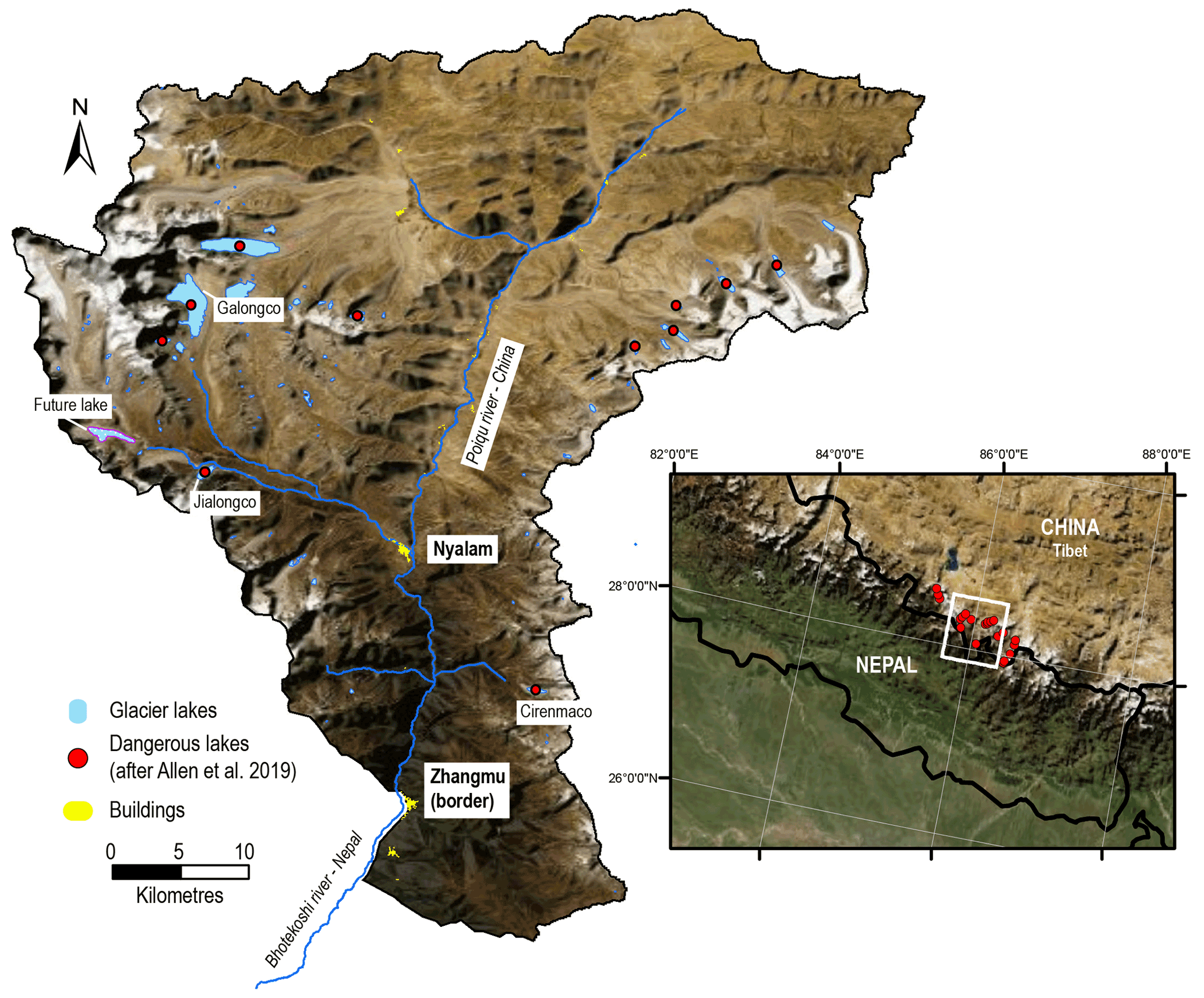
**Figure 1**Location of the Poiqu river basin within a hotspot of GLOF risk, as determined on the basis of the 30 potentially most dangerous lakes identified across Tibet (based on Allen et al., 2019). The current lakes focussed on in this study of Galongco and Jialongco are indicated, as is the modelled future lake, the county capital town of Nyalam, and the town of Zhangmu, through which the border between China and Nepal passes. Cirenmaco, from which several outburst floods have been reported, is also indicated. Background image: ESRI Basemap Imagery.
2 Study area
This analysis focuses on a ca. 40 km stretch of the lower Poiqu river basin originating from Galongco glacial lake, considering potential GLOF impacts in Nyalam town (capital of Nyalam county, Tibetan Autonomous Region), and downstream to the border with Nepal at Zhangmu (Fig.1). The elevation range of the study area extends over 6000 m, from the summit of Shishapangma at 8027 m a.s.l.$m a . s . l .$ (above sea level), whose glacierised slopes feed Galongco, to 2000 m a.s.l.$m a . s . l .$ in the river valley at Zhangmu. According to Jiao and Wang (2015), mean annual air temperature and mean annual precipitation in Nyalam (3810 m a.s.l.$m a . s . l .$) are 3.8 ∘C and 650.3 mm, respectively, with sub-zero temperatures lasting from November–March each year. Temperatures peak in July (10.8 ∘C), while the highest average precipitation totals are recorded in September (87.9 mm). In total, 60 % of the annual rainfall falls during the monsoon months of July–September (W.Wang et al., 2015).
The Poiqu basin is the Tibetan portion of the large transboundary Poiqu–Bhote Koshi–Sun Koshi River Basin, along which the economically important Friendship Highway links China to Nepal and where significant hydropower resources are located (Khanal et al., 2015b). Based on a larger study across Tibet, the Poiqu basin has been identified as a clear hotpot of transboundary GLOF danger (Allen et al., 2019; Fig.1), where at least six major GLOF events were reported over the past century, including repetitive events from Jialongco in 2002 (Chen et al., 2013) and Cirenmaco in 1964, 1981, and 1983 (Wang et al., 2018). The 1981 event resulted in numerous fatalities and estimated losses of up to USD 4 million (currency value in 2015) as a result of damage to houses, roads, hydropower, and disruption to trade and transportation services (Khanal et al., 2015a). Meanwhile, an outburst of 1.1 × 10 5 m 3 from Gongbatongshacuo (adjacent to Cirenmaco) in July 2016 resulted in significant damage to hydropower and roads, exacerbating losses inflicted 1 year earlier by the Gorkha earthquake (Cook et al., 2018). Whereas Gongbatongshacuo has completely drained, Cirenmaco remains a persistent threat, identified by multiple studies as being one of the most dangerous lakes in Tibet (Allen et al., 2019; S.Wang et al., 2015; Wang et al., 2018).
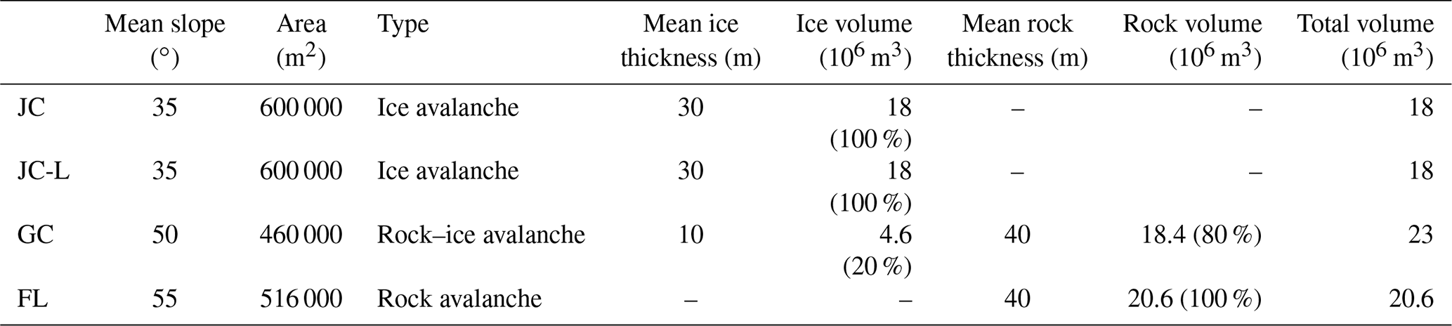
**Table 1**Input scenarios for rock and/or ice avalanche starting zones (see Fig.2) threatening Jialongco(JC), Galongco(GC), and the future lake(FL). Source areas are defined based on high-resolution satellite imagery. Mean ice thickness and resulting ice volume are based on GlabTop. Note that the JC-L scenario is defined for a lowered Jialongco lake, as the lake level has been lowered since 2019; see Sect.4.1 for further details.
 Download Print Version | Download XLSX

In the current study, we focus not on Cirenmaco, which has already been the subject of comprehensive investigations (Wang et al., 2018) but rather on the two other well-documented threats of Jialongco and Galongco, owing to their potential to cause damage to the Tibetan county capital of Nyalam and downstream in Nepal (Allen et al., 2019; Shrestha et al., 2010). In fact, after Cirenmaco, Galongco and Jialongco were ranked second and third, respectively, in a recent assessment of the most dangerous glacial lakes across Tibet, owing both to the physical characteristics of the lakes and their surroundings (see Sect.4.1) and to high levels of exposure in downstream areas (Allen et al., 2019). Both moraine-dammed proglacial lakes have expanded rapidly over the past decades, with Galongco, the largest lake in the basin, increasing its area by 450 % from 1.00 to 5.46 km 2 in the period 1964–2017 (W.Wang et al., 2015; Zhang et al., 2019). The potential future lake is located around 6 km further upstream from Jialongco (Fig.1– see Sect.3.2 for further description).
3 Methodological approach
In line with recent international guidance in GLOF hazard assessment (GAPHAZ 2017), in this study we consider lake susceptibility, which determines the likelihood of a given outburst scenario to occur, and use the GIS-based open-source numerical simulation tool r.avaflow to model the GLOF process chain and determine downstream impacts. In order to compare the threat posed by the two current lakes with an anticipated future lake, we focus on worst-case scenario modelling– that is to say, very large avalanche-triggered outburst events from Jialongco, Galongco, and the anticipated future lake.
3.1 Lake susceptibility and scenario development
The assessment follows a systematic approach that considers wide-ranging atmospheric, cryospheric, and geotechnical factors that can influence lake susceptibility and thereby the likelihood of a GLOF event occurring (after GAPHAZ 2017). We draw on remotely sensed data to the extent possible, complemented with field observations to enable a semi-quantitative assessment and comparison of susceptibility factors across the three lakes. Topographic characteristics (dam geometry, slope angles, etc.) and geological structures of the surrounding slopes were precisely measured using high-resolution 1 m Pléiades orthoimagery and digital elevation model (DEM), generated from 0.5 m resolution tri-stereo Pléiades imagery acquired in October 2018, covering the whole Poiqu basin (cf.Bhattacharya et al., 2021). Potentially unstable zones of glacial ice were identified in the imagery and Google Earth, based on orientation and density of crevassing, with a subsequent estimate of the ice thickness and volume provided from GlabTop model output (Table 1). Furthermore, the time series of Google Earth imagery was examined to identify any evidence of historical mass movements that could indicate an enhanced threat to the lakes below. Factors assessed, their primary attributes, and sources used are further described in Sect.4.1. Based on this assessment, and the recognition of a large ice- and/or rock-avalanche-triggered GLOF process chain being the most significant threat to all three lakes, avalanche source areas were identified as input for the process-chain modelling (Table 1).
3.2 Avalanche and GLOF modelling
The GLOF process chain was simulated with r.avaflow (Mergili et al., 2017; Pudasaini and Mergili, 2019), a GIS-based open-source simulation framework for multi-phase mass flows, which has the capacity to dynamically compute the interaction between triggering landslides (in this case rock and/or ice avalanches) and lakes. The model is also capable of computing debris flow hydraulics. Major model inputs include the initial avalanche source characteristics (Table 1), terrain data, friction and erosion parameters (see below), lake bathymetry, and volume.
Bathymetry surveys of Jialongco and Galongco were undertaken in 2019, using an unmanned vessel. The onboard GPS system achieves ∼ 2.5 m horizontal positioning accuracy, while the single-beam sonar sounder has a vertical accuracy of 1 cm± 0.1 %of depth measured. Contour maps of lake depths were interpolated by using Kriging geo-statistics. Maximum depths of 134 and 200 m were recorded for Jialongco and Galongco, respectively, while volumes based on the interpolated bathymetry were 40 and 590 × 10 6 m 3. Following the construction of an artificial channel and associated lowering of the water level in Jialongco, bathymetry was remeasured in 2021, giving a post-lowering maximum depth of 113 m and volume of 23.5 × 10 6 m 3.
For GLOF modelling from the future lake, the location, bathymetry, and volume of the potential lake upstream from Jialongco are based on a modelled overdeepening in the glacier bed topography using GlabTop (Linsbauer et al., 2012). The model is now well established for providing a first-order indication of where lakes may develop in the future (e.g. Allen et al., 2016; Haeberli et al., 2016; Linsbauer et al., 2016; Magnin et al., 2020). The ice thickness distribution from GlabTop is subtracted from a surface DEM to obtain the bed topography, i.e. a DEM without glaciers, from which overdeepenings in the glacier bed can be detected and volumes estimated. Inputs to the model include manually edited glacier branch lines, and a DEM– in this case the NASA Shuttle Radar Topography Mission (SRTM) Version 3.0 (void filled) – was used at 30 m resolution. While the model predicts several possible locations in the Poiqu basin where large future lakes can develop, we focussed on the largest of these lakes that threaten the town of Nyalam. Based on the modelled geometry of the overdeepening, a maximum future lake depth of 168 m and volume of 70 × 10 6 m 3 are estimated. The modelled bedrock topography forms the lake dam; i.e. the possible deposition of moraine on top of the bedrock, creating a higher dam structure, is not considered. Likewise, in keeping with a worst-case approach, we do not consider sediment deposition into the lake that will potentially reduce the volume and longevity of the lake (Steffen et al., 2022). Beyond its potential size, this overdeepening was selected owing to its position in an area of low surface gradient behind a pronounced terminal moraine, beneath a tongue where supraglacial ponds are already developing, and at an elevation that is lower than other overdeepenings in the area. All factors provide favourable preconditioning for the formation of a large proglacial lake (Frey et al., 2010; Linsbauer et al., 2016).
Depending on the defined GLOF process-chain scenarios (Table 1), we assume the mixture of one or two solid phases in the initial avalanche (rock component: _ρ_= 2700 kg m−3; ice component: _ρ_= 900 kg m−3) and one fluid phase (_ρ_= 1000 kg m−3) (lake water), where the ice / rock volume ratios are calculated based on the assessment in Sect.4.1. We define the damming moraine of the lakes as entrainment zones composed of the rock phase (representing glacier deposits) with a grain density of 2700 kg m−3. A simplified entrainment model is applied, which is a product of the flow momentum and the empirical entrainment coefficient (Mergili et al., 2017). However, the final erosion depths are dependent on the momentum of the particular process and are controlled by the entrainment coefficient. Other input parameters include the basal friction angle(_φ_) and the internal friction angle(_δ_) that govern the rheology of the flow. Here we set _φ_= 25∘ and _δ_= 10∘ for the initial stage of the process chain dominated mostly by the solid phase, i.e. avalanche, lake impact, and moraine erosion. For the downstream process from the moraine, we set _φ_= 25∘ and _δ_= 1∘ to model the flow as a water-saturated debris flow. The domain of the model is constructed such that it completely encompasses the avalanche source areas down to the China–Nepal border. All the simulations are executed for a total duration set to 1 h and 15 min (4500 s) providing enough time to evaluate the GLOF propagation downstream to the border. Finally, to evaluate the flow hydraulics obtained in terms of flow depth and discharge; we define three cross-sections along the flow channel located (i)immediately downstream of the damming moraine, (ii)at Nyalam (nearest settlement), and (iii)at Zhangmu (China–Nepal border).
It is to be noted that we assumed no entrainment of the frontal moraine in the Jialongco lowered scenario(JC-L), as the damming moraine was lowered by up to 15–20 m and armoured with concrete as a part of the engineering works performed for GLOF mitigation since 2019. For GLOFs originating from the future lake we evaluate the cascading impact of the flow into Jialongco, located ∼ 6 km downstream (see Fig.1). While several freely available DEMs were tested (e.g. ALOS PALSAR at 12.5 m or High Mountain Asia DEM at 8 m), topographic artefacts led to modelling errors. As such, the 1 m Pléiades DEM was finally used for all simulations (based on imagery from 2018, with the exception of the JC-L simulation which used an updated DEM from 2021 for the dam area).
3.3 Future lake development
Previous studies (e.g. King et al., 2018; Quincey et al., 2007) have identified glacier surface attributes which may precondition the surface of debris-covered glaciers for supraglacial lake development. Glaciers bounded by large lateral and terminal moraines which have a flat or gently sloping (<∼ 2∘), slowly flowing (<∼ 10 m a−1) main tongue are hotspots of supraglacial pond development as surface meltwater cannot drain from the glacier surface (e.g. King et al., 2018; Quincey et al., 2007). Such pond networks expand when the mass balance of the glacier is negative and coalesce to eventually form a supraglacial lake at the hydrological base level of the glacier – the lowest point where the glacier surface intersects the terminal moraine (Figs.3 and 19 in Benn et al., 2012). Large supraglacial lakes located close to the termini of debris-covered glaciers can persist for decades, over which period they expand, deepen, and eventually transition to become proglacial lakes, such as Galongco and Jialongco. By examining contemporary and historical glacier surface velocity and elevation changes, it is therefore possible to identify glacier surfaces suited for surface meltwater ponding, which represent current and future sites of supraglacial lake development. To establish the possibility of lake development and the likely future trajectory of lake area growth on the parent glacier up-valley from Jialongco (RGI60-15.09475), we examined the surface velocity, rate of thinning, and the evolution of the geometry (surface slope) of the glacier in recent decades.
We used the Pléiades DEM and glacier surface elevation change data generated by King et al. (2019) to examine the evolution of the geometry of glacier RGI60-15.09475 since the 1970s. Glacier surface slope estimates were derived by the fitting of linear regression models through “average” (mean of five evenly spaced) elevation profiles of the glacier surface split into 750 m long segments (King et al., 2018). We also assessed the current flow regime of the glacier using surface velocity data, which were generated through the tracking of glacier surface features visible in Sentinel 2 imagery over the period 2017–2019 (Pronk et al., 2021). Examination of these parameters established that the conditions at the surface of the glacier (Fig.7) are well suited for imminent glacial lake development considering the factors outlined by Quincey et al. (2007), namely low (< 2∘) surface slope, negligible ice flow (< 10 m a−1), and sustained glacier thinning.
To investigate the likely size of such a lake in the coming decades we consider two different scenarios of glacier thinning between 2015 and 2100 and follow a similar method to that of Linsbauer et al. (2013) to simulate glacier thickness into the future but employ different criteria to determine future lake area. Our first scenario is based on the assumption that the acceleration in glacier thinning in the Poiqu basin measured by King et al. (2019) is replicated by the year 2100. Such an increase in thinning will be driven by a further 1∘C increase in temperature by 2100 (Kraaijenbrink et al., 2017), in addition to the ∼ 1∘C increase in temperature which has occurred in the central Himalaya (Maurer et al., 2019) since the 1970s. The second scenario is based on the premise that the increase in thinning which occurred between 1974 and 2015 will be replicated over subsequent equivalent time periods (by 2056, 2097, etc.). We extrapolated the thinning rates from King et al. (2019) and integrated the resulting elevation changes between 2015 and 2100. We then assumed that once the glacier surface had lowered to a height below the hydrological base level of the glacier (4890 m a.s.l.$m a . s . l .$), meltwater ponding would occur and that DEM pixels with an elevation of less than this threshold represented lake area at that point in time.
4 Results
For Jialongco, Galongco, and the potential future lake, we focus below on results relating to the susceptibility of the lakes to produce an outburst event, as well as the potential magnitude of downstream impacts, as simulated under worst-case scenarios. A full hazard and risk assessment, including a complete range of outburst scenarios and vulnerability mapping, is beyond the scope of this study.
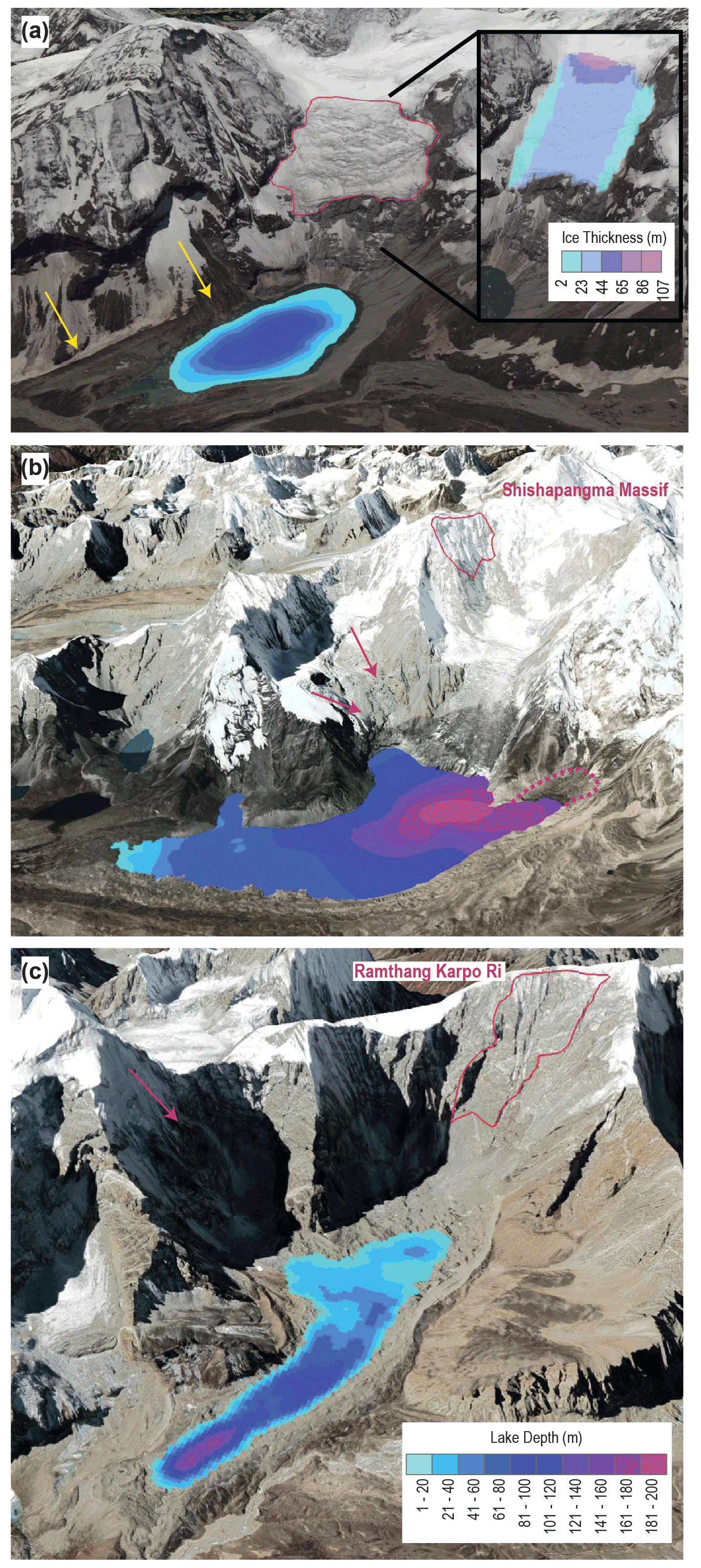
**Figure 2**Rock and/or ice avalanche starting zones (in red) used as input scenarios for the modelling of outburst flood process chains from the three lakes (see Table 1 for details). **(a)**Jialongco: the inset shows the GlabTop-modelled ice thickness of the ice avalanche source area, and yellow lines indicate the steep lateral moraine walls also threatening the lake (see also Fig.9). **(b)**Galongco: large rock and/or ice avalanche source area outlined in red, while arrows indicate smaller source areas of unstable ice, with possible future expansion of the lake shown by the dashed line. **(c)**Projected future lake: large rock avalanche source area outlined in red, while the arrow indicates the possible source area of smaller ice avalanches. Measured (and interpolated) lake bathymetry is shown in**(a)** and**(b)**, with modelled bathymetry of the future lake**(c)** derived from GlabTop. Background imagery from ©Google Earth.
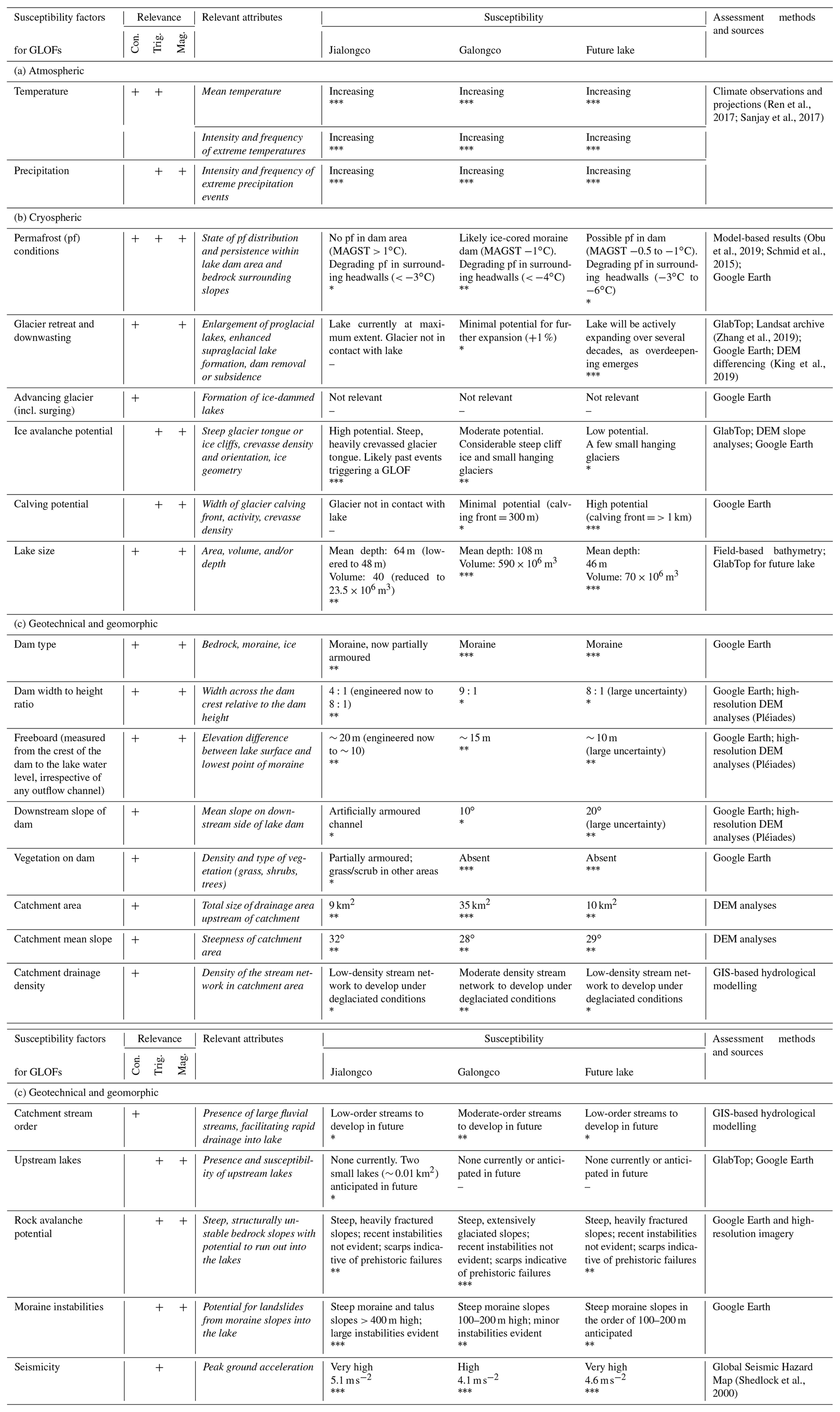
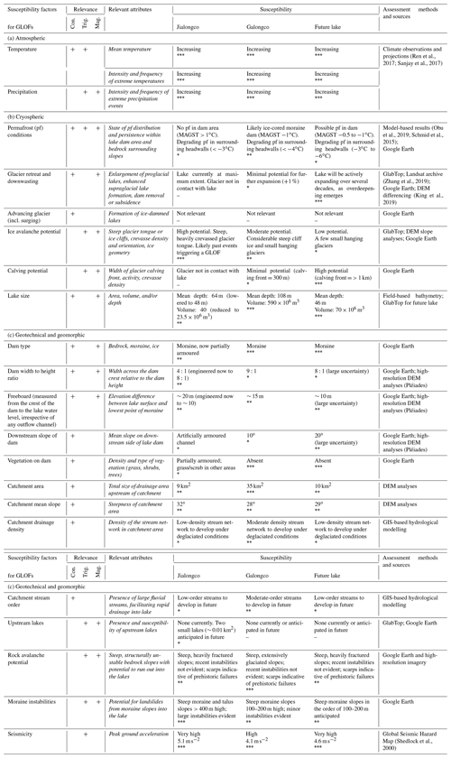
**Table 2**First-order assessment of wide-ranging factors determining the susceptibility of glacial lakes (based on GAPHAZ 2017). An expert assessment of high(∗∗∗$^{* * *}$), moderate(∗∗$^{* *}$), and low(∗) susceptibility for each of the factors is indicated. Factors not considered relevant for these lakes are indicated with–. Factors can be relevant for conditioning(con.) and/or triggering(trig.) a GLOF and can also have an influence on outburst magnitude(mag.).
 Download XLSX
4.1 Lake susceptibility and scenario development
The susceptibility component of GLOF hazard assessment establishes the likelihood of an event from a given lake, considering the wide-ranging factors that can condition or trigger an outburst. The likelihood (which can be both qualitative or quantitative for some hazards) is always specific to a given magnitude and valid for a given time frame, recognising that susceptibility can evolve over time (Allen et al., 2022). Based on this assessment, scenarios for hazard modelling can be established, including worst-case outburst scenarios as we focus on here. Taking a systematic approach (after GAPHAZ 2017), we compare the relative susceptibility of the three lakes considered in this study, considering also how this susceptibility might evolve in the future (Table 2). The table distinguishes those factors that condition and/or trigger an outburst event while also linking to those factors that inform about possible outburst magnitudes.
Located in a transitional zone to the north of the main Himalayan divide, the upper Poiqu basin is subject to heavy rainfall during the Asian summer monsoon. With a significantly larger watershed area, Galongco is considered more susceptible to heavy rain and/or snowmelt leading to high lake water levels, and under future deglaciated conditions the lake may become fed by a well-developed paraglacial stream network. However, even under these conditions, the relatively favourable dam geometry (large width to height ratio and 15 m dam freeboard) suggests that the likelihood and magnitude associated with an outburst via this triggering mechanism is low. Similarly, self-destruction via warm temperatures and melting of ground ice within the moraine dam is extremely unlikely. Creeping permafrost features visible in the vicinity of Galongco, modelled mean annual ground surface temperature (MAGST) (after Obu et al., 2019), and a partially hummocky appearance of the lake dam suggest a strong likelihood of a partially ice-cored moraine, but the huge width (> 200 m) and gentle downstream slope of the dam would make a catastrophic failure in the case of thawing extremely unlikely.
As with the majority of large glacial lakes across the Himalaya (Liu et al., 2013; Richardson and Reynolds, 2000; Sattar et al., 2021), the main triggering threat is considered to come from large slope instabilities, impacting the lake. Under current conditions, Jialongco is assessed to be most susceptible to ice avalanches, given the presence of a steep, highly crevassed tongue positioned directly behind the lake (Fig.2a). With an average slope of 35∘, large transverse crevasses marking a sharp break in topography, and likely temperate conditions at the bed, a full collapse of the glacier tongue (∼ 18 × 10 6 m 3) is considered a feasible worst-case scenario (Table 1). The mass would impact the lake in a direction parallel to the longitudinal axis of the lake, leading to maximum overtopping wave heights and a swashing effect. Smaller ice avalanches from this glacier triggered GLOFs from Jialongco in 2002, at a time when the lake was less than half of its current size (Chen et al., 2013). While atmospheric warming is expected to increase temperatures and meltwater at the glacier bed (Kääb et al., 2021), potentially reducing the stability of the glacier, warming-driven retreat of the tongue will see a reduction in the potential avalanche volume over time, and eventually, this threat will be eliminated completely as the ice retreats to a flatter plateau. In comparison, the partially debris-covered parent glacier tongue of Galongco has a gentle mean slope(18∘) and uniform gradient. Potential unstable ice masses threatening Galongco, from steep ice cliffs and hanging glaciers, are found higher up on the mountain (Fig.2b), with estimated maximum volumes in the range of 0.1–1 × 10 6 m 3. Avalanches from the larger of these starting zones would strike the lake perpendicular to the longitudinal axis of the lake (from the west), meaning most of the energy from a displacement wave would be dissipated on the opposing side of the lake. It is a similar situation above the future lake, where small and comparatively thin hanging glaciers are restricted to the slopes southwest of the potential lake (Fig.2c).
Hence, a large rock or combined ice–rock avalanche is considered to be the most feasible mechanism capable of triggering a worst-case GLOF from either Galongco or the potential future lake. The northeast-facing slopes of Shishapangma rise nearly 3000 m above Galongco and are likely to be mostly underlain by cold permafrost conditions. This is inferred both from the distribution of rock glaciers in the region, extending down as low as 4000 m a.s.l.$m a . s . l .$ (Bolch et al., 2022), and modelled MAGST (Obu et al., 2019) (Table 2). However, the presence of ice cliffs and hanging glaciers can lead to thermal perturbations and even melt conditions in otherwise very cold environment (Shugar et al., 2021). Based on close examination with high-resolution imagery, a large potential starting zone extending from 6550–7340 m a.s.l.$m a . s . l .$ was identified on a heavily fractured slope beneath the south ridge of Shishapangma (Fig.2b). Here, as in the surrounding peaks, layered leucogranite sits above sillimanite gneisses with a gentle northerly dipping schistosity (Searle et al., 1997). The slope has been eroded and is potentially oversteepened by the glacier below. Based on structures outcropping on the face, a 40 m maximum bedrock depth was assumed, while steep ice cliffs and firn covering the slope is estimated to not exceed 10 m, resulting in a combined starting volume of 23 × 10 6 m 3 (20 %ice and 80 %rock). The potential future lake is positioned directly beneath the ice-free ∼ 2000 m high eastern face of Ramthang Karpo Ri (Fig.2c), where MAGST is in the range of−3 to−6∘C. The face is dissected by numerous vertical structures, and there is evidence of several scarps from previous instabilities. A large potential source area was identified, comparable to the Galongco scenario, with scarps on the face suggesting similar maximum depths of up to 40 m, leading to a total rock avalanche volume of 20.6 × 10 6 m 3 (Table 1).
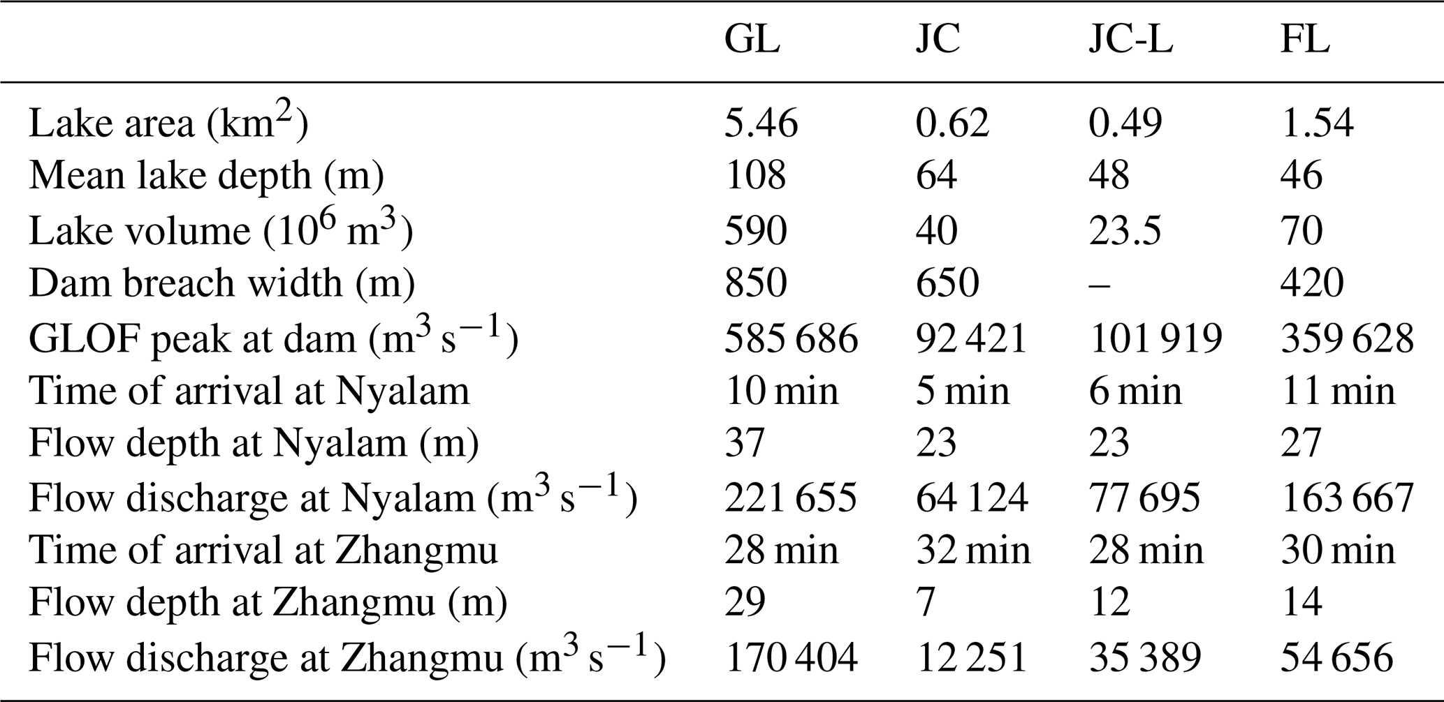
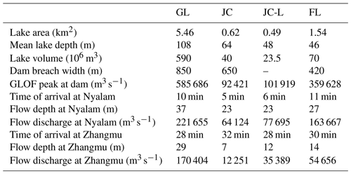
**Table 3**Measured and modelled lake and outburst flood parameters for Galongco(GL), Jialongco pre-lowering(JC), Jialongco post-lowering(JC-L), and the future lake(FL). All timings are relative to the start of the initial rock and/or ice avalanche.
 Download Print Version | Download XLSX

Even on a global scale, ice and/or rock avalanche volumes of the magnitude included in the scenarios here are rare (Kääb et al., 2021; Schneider et al., 2011), although they have occurred recently (Shugar et al., 2021) and prehistorically (Stolle et al., 2017) in the Himalaya. While Poiqu basin is located within a high seismic hazard zone (Shedlock et al., 2000), it is notable that the 2015 Gorkha earthquake did not cause any large ice and/or rock avalanches in the Poiqu basin despite significant damage in Nyalam and along the highway to Nepal (Kargel et al., 2016). Hence, given a lack of historical large instabilities in the basin, ice and/or rock avalanches of the magnitude included in this study are assessed to be low to very low likelihood events (see also Sect.5.2). Geologically there is little basis for distinguishing between the likelihood of bedrock failures above the three lakes, and permafrost conditions are comparable (Table 2). Owing to the position of Jialongco directly beneath a steep glacier tongue, the history of ice-avalanche-triggered outburst events, and more unfavourable dam conditions (low freeboard, narrow width), we assess a worst-case outburst from this lake to be more likely than from Galongco under current conditions. Finally, all three lakes are or will be susceptible to instantaneous or progressive landslides occurring from the adjacent lateral moraines, most notably for Jialongco where active instabilities are clearly evident (Fig.2a). Recent studies have shown that large lateral failures, either instantaneous or progressive, can be sufficient to initiate catastrophic process chains where dam geometries are sufficiently prone to erosion (Zheng et al., 2021b).
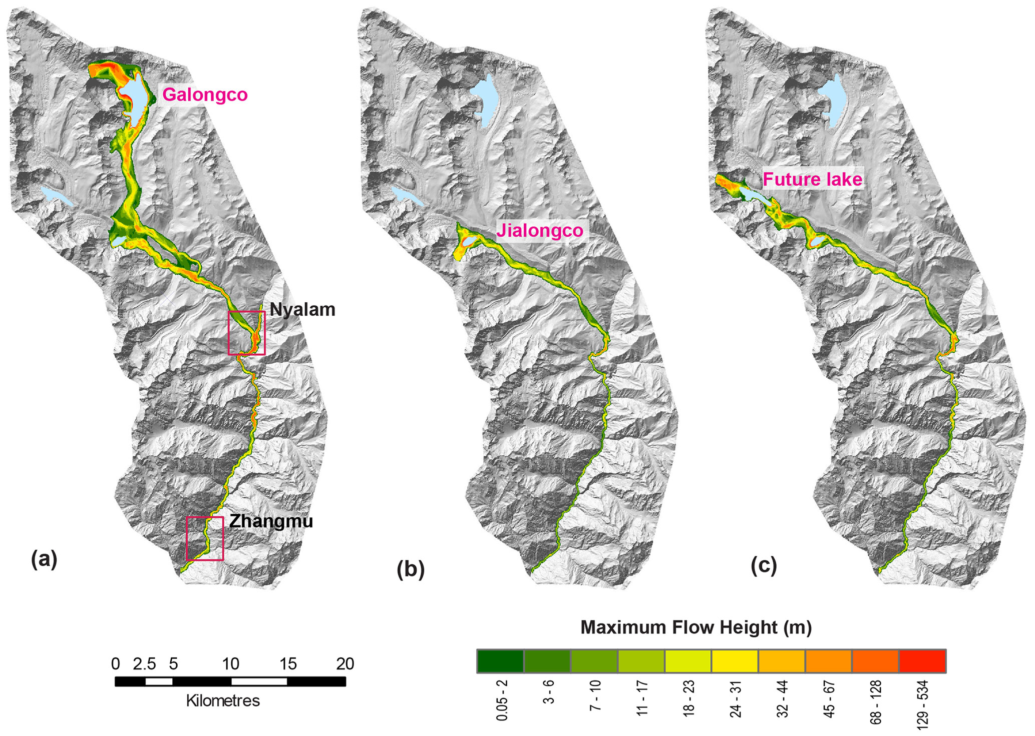
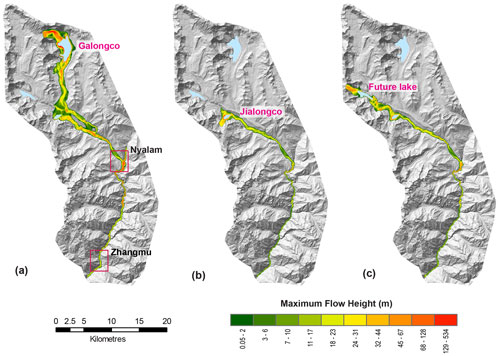
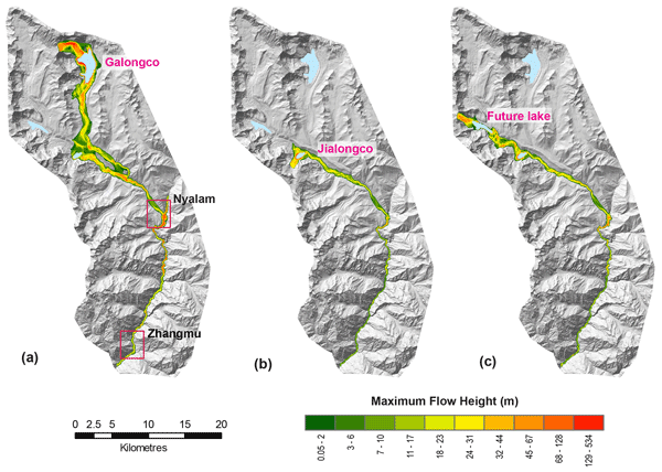
**Figure 3**Modelled GLOF flow heights for worst-case scenarios from **(a)**Galongco, **(b)**Jialongco (JC-L), and **(c)**the potential future lake. The location of Nyalam and Zhangmu towns are indicated by the red boxes in**(a)**.
4.2 GLOF modelling
Worst-case outburst scenarios for the three lakes were simulated until the border between China and Nepal (town of Zhangmu). The modelled flow does not extend beyond the border owing to the limited coverage of the required high-resolution Pléiades DEM. Of the two current lakes assessed, the modelled peak discharge from Galongco is more than 5 times larger than that from Jialongco, leading to flow depths of up to 14 m higher impacting the town of Nyalam (Table 3, Figs.3 and 4). At the border, 20 km downstream, inundation depths are up to 17 m higher for the Galongco simulation, as the large volume of water becomes constricted in the narrow topography of the valley, with discharge values remaining above 100 000 m 3 s−1 even after 1 h (Fig.4). The simulated worst-case outburst from the potential future lake has a calculated peak discharge at the dam of 359 628 m 3 s−1, resulting in flow depths (27 m) and discharge (163 667 m 3 s−1) in Nyalam that would exceed those of Jialongco but are an order of magnitude lower than from Galongco. Differences in the shape of the outflow hydrographs at the dam (Fig.4a) and travel distance lead to minor variations in the arrival of the modelled flood waves in Nyalam and further downstream at the border with Nepal. The flood wave from Jialongco first registers after 6 min in Nyalam, with the maximum flow heights arriving 2 min later (all times relative to the initial avalanche release). In contrast, the flood wave from Galongco first registers after 10 min, with maximum flow heights arriving 4 min later. An outburst from the potential future lake has a similar arrival time of only 11 min in Nyalam, while all simulated outbursts reach the Nepalese border within a range of 28–32 min after the avalanche release. Notably, the remedial measures undertaken at Jialongco, which have lowered and armoured the lake dam (erosion set to zero in the model– see Sect.3.2), result in a slightly larger initial peak discharge (Table 3, Fig.4) because there is a greater splashing effect and larger overtopping volume owing to the reduced freeboard. Downstream, the simulated GLOF then attenuates at a slower rate (54 % decrease in discharge between Nyalam and Zhangmu) compared to the simulation for the original lake (81 %decrease in discharge between Nyalam and Zhangmu) (Fig.4).
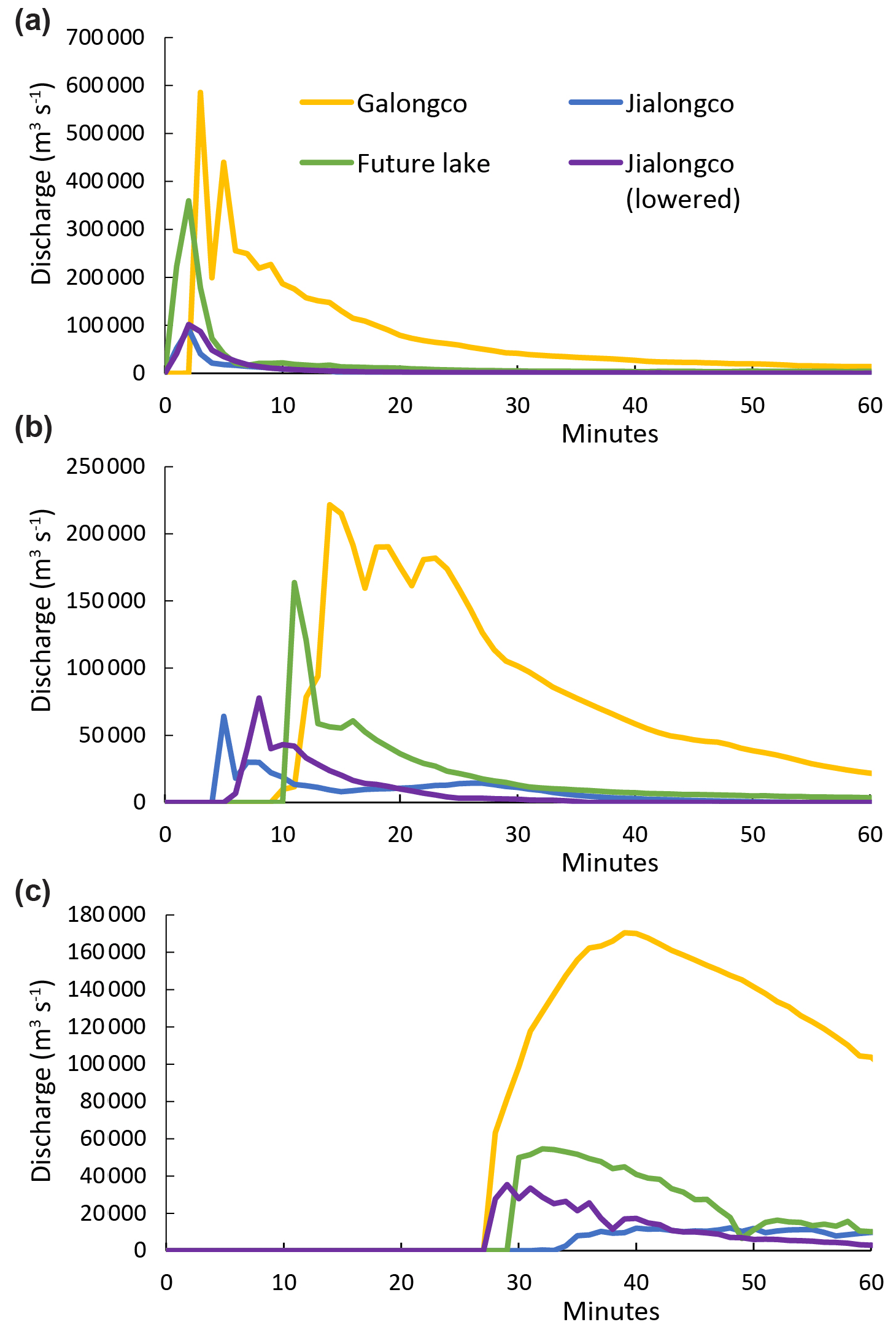
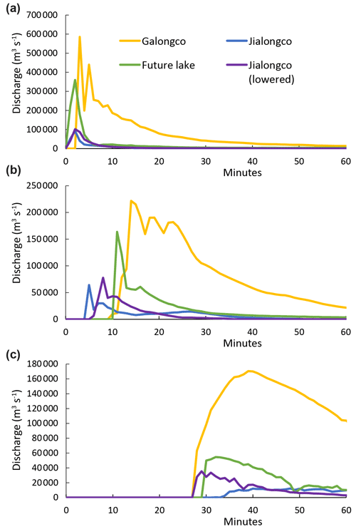
**Figure 4**Modelled GLOF discharge for three assessed lakes taken at **(a)**the lake dam, **(b)**Nyalam, and **(c)**Zhangmu.

Potential processes that could further enhance the GLOF magnitude include entrainment of large volumes of sediment along the flow path leading to additional bulking of the flow volume, blockages of a river by GLOF deposits leading to secondary